My Key Lessons from This Project
I’ve been working on this boundary issue in dense woods and valleys, and here’s what I learned from hands-on experience (I’m a logger, not a licensed surveyor).
The biggest game-changer was switching correction services:
-
Ditch PointPerfect MQTT corrections ($8/month) — I constantly lost RTK Fix in deep woods/valleys.
-
Switch to the new RTCM/NTRIP service ($15/month) — It performs much better. I now hold RTK Fix (and sometimes even get it) in places where I previously couldn’t even achieve RTK Float with MQTT.
Background on the Boundary
-
We had copies of both my deed and my neighbor’s deed.
The shared line in question: exactly 2,677.76 ft long. -
Both deeds agree perfectly on the compass bearing and distance.
-
One end had a capped pin (good monument).
-
The far end referenced a long-gone tree (no stump within ±30 ft).
No marker at the far end, except for a mentioned fence line that goes along 4 properties in a fairly straight line.
My Actual Workflow
-
Collected field data with my RTK Torch using FLEX RTCM/NTRIP corrections:
-
My property: 2 capped pins + 5 uncapped monuments (30+ deed calls).
-
Neighbor’s property: 3 capped pins + 2 uncapped monuments (~12 calls).
I used Andrew’s Deed Plotter tool to generate KML files from the deed calls.
-
Created KML overlays for my 63-acre property and the neighbor’s 62-acre property (both very irregular shapes) using the various corrections options, Ground Distance, RTK Localization, RTK Scale, etc
-
-
Aligned the KMLs on the shared capped pins and other monuments → they matched within 1–2 inches at those points.
-
At the far (uncapped) end of the 2,677.76 ft line, the KML overlays showed a 2-3ft discrepancy.
Here’s what overlapping boundary lines can look like when viewed in Google Earth:
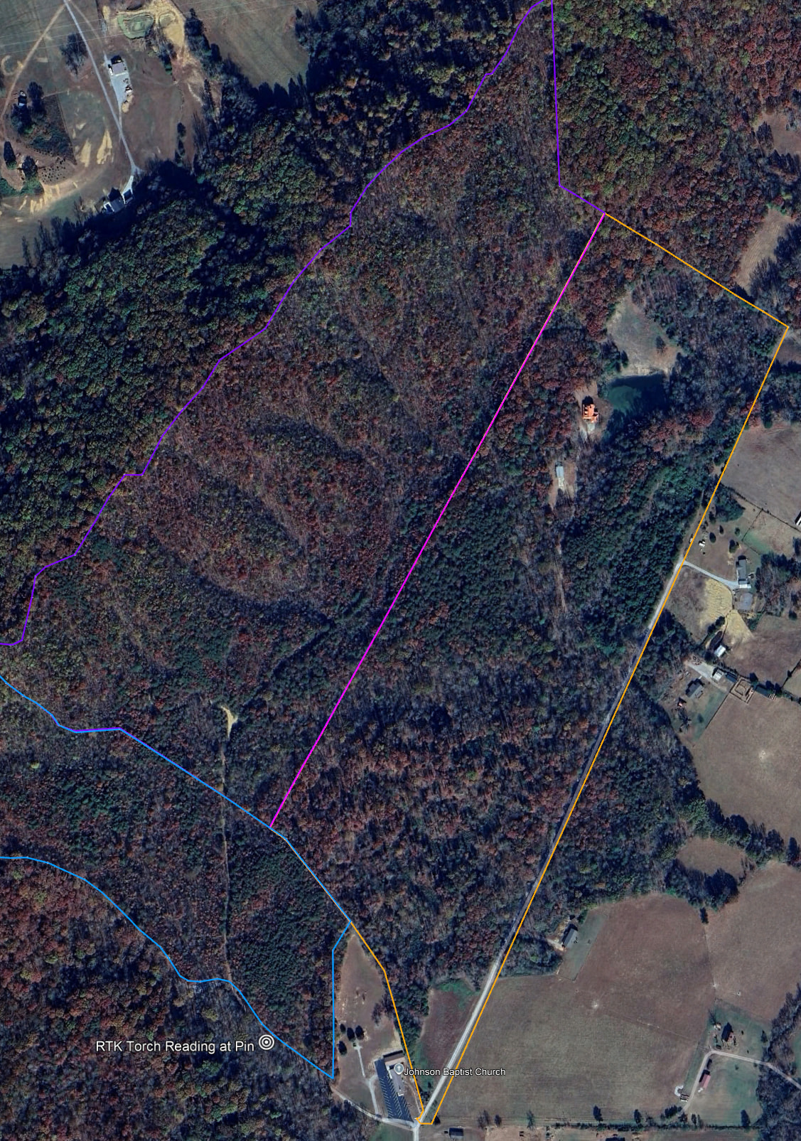
At the north border below, no monument other than fence line

-
Fortunately, this was along a fence line mentioned in both deeds → strong physical evidence we were in roughly the right place (±3 ft was acceptable).
- We weren’t building a permanent fence — just a firebreak/dirt trail — so minor differences along the length were fine.
-
I loaded both color-coded KMLs into SW Maps on my Android Tablet.
-
Walked the entire line from the uncapped end.
-
Dropped pink flags every 50–100 ft (spacing depended on visibility through the woods)
-
-
My neighbor walked the flagged line afterward and agreed: “Good enough” for our non-permanent purpose.
Recommended Workflow (Potentially One Trip if You Have a PC in the Field)
-
Get copies of the deed(s) for the area in question.
-
Locate and record every monument you can find (capped/licensed ones especially, plus any uncapped).
-
Input all the data (calls, bearings, distances, monument coordinates) into Andrew’s Deed Plotter → https://845.ddns.net/deed-plotter.html
-
Export multiple KML versions (try different adjustment/correction methods; use different colors for each).
-
Review/compare the KMLs on a PC in Google Earth Pro (or in the field if you have internet to access the tool)
-
Choose the version that best matches the physical evidence — prioritize in this order:
-
Capped/licensed pins
-
Other physical monuments
-
Your own RTK measurements
-
-
Load the best color-coded KML(s) into SW Maps.
-
Head to the field and flag your line (e.g., every 50–100 ft along the 2,677 ft boundary).
-
Extra option - I actually drew two lines in GOOGLE Earth Pro going from the Capped Pin up the middle between the two initial KML Boundaries to help me place flags more accurately at the uncapped end. Those two lines per Google Earth were at N28.49E and N28.48E, close to N29.15 from both deeds (N29degrees 9minues East, but can’t be explained via Magnetic declination, age of deeds 1960, 70, 80’s)
Important Lessons I Learned
-
Old deeds are amazingly accurate on distances (chains were great!).
-
Compass bearings are less reliable — declination, poor compasses, or no correction for magnetic variation were common.
-
Trust the monuments first, distances second, and deed bearings as guidance (not gospel).
This worked because my neighbor was cooperative and curious. Your results may vary — especially if the neighbors aren’t on board. Always remember: I’m not a licensed surveyor — this is just what worked for our low-stakes firebreak project.
Hope this helps make your own boundary work smoother!
Thanks for all the help from @rftop @AORPLS @Andrew74 , @sparky