PostCard with external battery, no shield, a proven L1/L2/L5 helical antenna
RTK_Everywhere_Firmware_RC-Sep_04_2025.bin on the PostCard
LG290P03AANR01A03S_PPP_TEMP0812 FW on LG290P
Only GPS and Galileo Constellations used, plus E6 Corrections with 18-20 SIV
SW Maps (Android) used and a Bluetooth Serial Terminal to make changes to FW
stable tripod mount
NMEA only reports RTK Float (not Fix), as others have mentioned and the Quectel FW readme.txt.
The PPP appears to initially converge in the typical 15-20 minutes. Before convergence the positions are generally worse than L1/L2/L5 DGPS.
On the first setup, the solutions stabilized about 1m Northwest from known coordinates. This could easily be a reference frame issue and not a concern of mine during initial testing (easy fix later).
I moved the antenna (slowly walking around) ~100’ and returned the Device to the Tripod. Now the coordinates are about 1m to the East. I repeat this procedure many times with random outcomes.
Dumping the antenna requires re-acquisition & convergence and when the position does settle in, it may or maynot be in the original location….easily 1m off in any direction. Allowing another 20 minutes for PPP convergence doesn’t always fix it.
These results are similar to other Hardware that I’ve tested for HAS this year, for a “backup” real-time correction source. I can’t get repeatable results in real-world conditions using HAS in the Southeastern US.
I truly hope I’m simply missing the magic setting/button somewhere
It seems the situation is clear, when I saw the graph posted by Sparky I had confirmation that the Galileo HAS system still has to mature, You have definitely sealed the sentence.
Very good summary.
In the end, I think the YouTube videos from South with accuracy below 10 cm are urban legends, jaja.
I also saw some CHCnav videos with the I76 equipment with PPP-Beidou, and they achieve things below 10 cm on the screen.
But with our low-cost equipment, we’re far from 10 cm for now.
Hope springs eternal.
We’ll continue investigating.
Best regards, everyone.
Angel
I would tend to believe them. Beidou is very accurate for it’s specific region (China). I’ve always believed the geostationary sats in the Beidou constellation helps a lot.
And to be completely fair, I’m sure Galileo-HAS works much better in the EU than it does for me in the US.
These are improving over time, when you look back at older reports
Let’s consider the GPS constellation only for now.
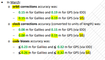
After our GNSS device applies the HAS/E6 corrections, the 3 error sources listed are still 19cm (orbit), 15cm(clock), and 32cm(code) - each independently contributing to the final position error. And we have no atmospheric correction yet.
My personal application:
I want to use HAS/E6 as a “backup” real-time correction source when NTRIP(Cellular Service) isn’t available at a location (which is rare in my region). In this case, I’d rather collect a DGPS or even an autonomous position and mark the point as such, and keep on moving. If that particular asset/location is semi-important, a ~30 minute post-processed PPP solution serves me better than waiting 20 minutes for HAS convergence where I still have to “hope” that I get a good solution. If the elevation is important to me (in this No Cellular Service example), then a real PPP mission (longer occupation times & it’s quality report) is required anyway.
I think HAS/E6 is a great free service and provides a real benefit…..it’s just not ready to be compared to RTK performance. I’m afraid most of us have to wait for at least Service Level 2, when regional atmospheric corrections are planned to be provided over E6.
Again, these are just my personal opinions
I hope I’m wrong because I really want to be using HAS/E6 as a free backup correction source.