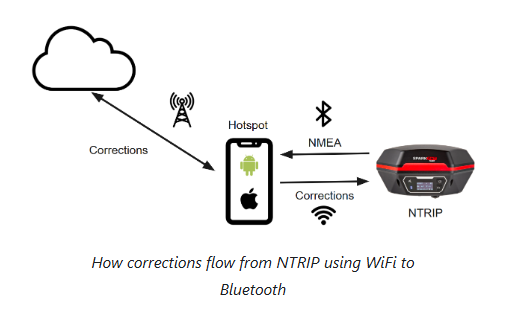
Generally speaking, you need to enter those NTRIP credentials into your GIS app. The GIS app then passes the corrections over Bluetooth to the RTK device. Docs for the FPX-T are here, namely checkout the quickstart guide showing how to use the NTRIP Client in SW Maps.
(Above) If you want to get technical, you can also enter the NTRIP credentials into the FPX-T unit itself, and then give the FPX-T WiFi credentials to the hotspot on your phone, but that’s usually only required for iOS users or other cases where the GIS app does not have an NTRIP Client built in. Docs are here.
Also note - we’ve split SparkPNT away from SparkFun. If you need technical help with your FPX-T, please checkout the SparkPNT forum - but don’t worry, we’ll help you wherever you are.
Yes I’m aware, that’s why I’m trying to improve accuracy from every angle on this project. We’re laying fiber into some pretty remote and covered areas, we need as much accuracy as possible.
RTK (base station observations) offer no significant benefit against canopy interference because differencing only eliminates shared, atmospheric errors between the two receivers. Canopy errors—like signal attenuation, diffraction, and multipath reflections—are strictly localized to the rover. Because the base does not experience these unique physical disruptions, it cannot provide data to cancel them out, leaving the rover’s RTK algorithm to struggle against uncorrectable, local noise.
Under dense canopy, a RTK receiver can transition into FIXED mode and output a solution all while being completely wrong. That’s worse because it gives the user false confidence in the accuracy of the solution. A solution that “appears” to be good to 2cm can actually be 2m easily, due to the local errors caused by the canopy.
I’m not aware of any magic bullet that allows GNSS to function under significant tree canopy, for applications when accuracy is required. Additional tools are required for that workflow.
Real World talk: Naturally, we all collect points in challenging situations when we don’t have a choice. My advice is to flag those points in a manner that shows users to not expect any particular accuracy at those locations, such as under tree canopy.
What about getting an RTK fix outside of the canopy and targeting the POI with a laser? I met Laser Tech a few weeks back and was given this impression ‘this is what they did’. We keep trying to get a demo unit for testing with our equipment and have failed, but are there other tools that may allow us to stand outside the cone of silence (tree canopy) to get work done?
Great Point @sparky. In the late 90’s we used a Laser Atlanta gun that would work with a Trimble Backpack unit.
The Laser would provide the data collector with a distance and bearing to the target, as an offset to project the GPS point. Yup, it was “just” GPS back then
SA was still active, so the workflow was heavy into post processing. The bearing error wasn’t an extreme issue with the overall precision back then. [Edit] Azimuth would be the correct term, not bearing, sorry.