I found that the GPS-RTK-SMA ZED F9 - P card returns a series of equal heights, even though the real situation is different +/- 10 cm, I ask if it is possible to modify the sensitivity to a higher precision. I attach a screen of the points taken

You can run through our accuracy verification guide Accuracy Verification - SparkFun RTK Product Manual to double-check
How far away is your correction source, and what is it?
the station is 10 km away
How is it configured now? Using data in what form? Receiving RTCM3 adequately? It’s getting a new fix? Perhaps show data as output directly by the board.
So SparkFun GPS-RTK-SMA Breakout - ZED-F9P (Qwiic) - GPS-16481 - SparkFun Electronics but how exactly?
If using NMEA output, make sure High Precision mode is enabled to provide additional decimal places for Lat, Lon, Alt…
0x10930006 CFG-NMEA-HIGHPREC = TRUE (1)
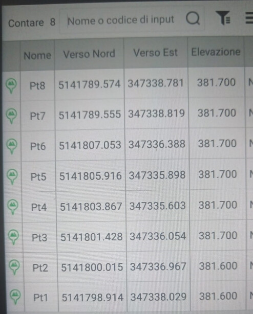
good morning, I changed the variable to high precision, but it only adds one digit, unfortunately I am a surveyor and I have no skills in ublox, I checked in the field software and the precisions are within 5 cm, I attach a screen. I do not understand why it records the height with a 10 cm step, can you help me thanks !!
U-Blox has u-center app for personal computer with MS Windows to support the ZED-F9P module available at u-center | u-blox. This application also supports RTK.
Have you updated the firmware of this module? If not, you need to do it. Latest firmware version 1.51 and is available here ZED-F9P module | u-blox
The image attachment didn’t work.
Is it reporting Minutes to 7 decimal places in the NMEA output? That should resolve sub-cm. The height should be metres to 3dp, for the “High Precision” reporting.
Is the complaint here the Precision or the Accuracy?
What is the software?
My guess is that’s a result of your Software.
Could be the resolution of the gridded Geoid File (if used) and the app is dropping digits after the Ortho Calculation (which is incorrect). It’s unclear if those are Ellipsoidal or Ortho Heights in the Screenshot.
The good news is this isn’t a limitation of the F9P, when configured appropriately as @clive1 has already mentioned.

the problem occurs on both surpad 4.0 and FieldGenius
How do I check the firmware version?
how do i check the decimal digits of NMEA?
sorry but i’m not good at settings
the coordinates are in the utm33 reference system, the x,y position works very well with centimeter precision
Thank you
Run u-center app
Connect the application to the module:
Click on the menu Receiver->Baudrate->115’200
Click on the menu Reveiver->Connection->COM
Click on the menu View->Messages view
Navigate to UBX → MON → VER (Version)

For RTK testing with u-center it is best to install this application on a laptop.
Thanks for the replies, I updated the module as indicated, but now I have problems with the Bluetooth connection, before the update it worked correctly, is it necessary to set some parameters within ucenter?, thank you very much.
Ok, but the board doesn’t have BlueTooth.
What exactly have you wired to what? What worked correctly, what were the settings THEN.
If you’ve connected the BlueTooth to UART2 perhaps double check what baud rate and messages you’ve chosen to use.
Also ensure your other BT device is in a compatible mode (BLE for iOS, Android should be good-to-go)
The bt is connected to UART2, the speed parameters are correct RTCM3 - 118500, the module worked fine with update 1.3 and android, how do I know which messages I should use? Thanks
The BT works, but when I turn it off and on again, it doesn’t keep the UART2 port configuration changes and it doesn’t work anymore, what can I do, thanks
Make sure the UBX-CFG-VALSET configuration items are going into FLASH (+BBR+RAM)
What BT board are you using, I don’t see it mentioned in the thread?
Everything works, thanks
But despite the update, the measurement persists every 10 cm. The card’s technical specifications specify accuracy of 1 cm on the three xyz dimensions. I can’t figure out why I can’t achieve this level of accuracy. Perhaps it has something to do with the acquisition frequency?