Hello, I am very new to all of this but was looking for a product recommendation for my use case. I am working on base maps for ~1-2 acre properties and am using a Bluetooth RTK Module from ArduSimple. I can occasionally get to FIX accuracy, however connection quickly gives out around trees and houses. I am looking for a simple base station I can set up within a few minutes from my car so my scanner can get ~1 cm accuracy. What is the easiest and cheapest way to go about this?
Welcome @Cael !
Answers can range from fairly simple to extremely complicated, depending on what you need to accomplish from the GNSS positions, and if you truly mean “1 cm Accuracy”.
Is the main intention (of the RTK points) to geolocate the final output (3D model) from the scans?
Or do you intend to use the RTK points (targets) during the 3D model reconstruction as Hard Control Points ?
I’m only asking because both are valid uses, but have very different requirements and workflows.
What correction source are you using currently?
Having a local base doesn’t provide much magic or immunity to obstructions experienced by your Rover such as the trees and houses you mentioned. A shorter baseline does have advantages, but not without taking a lot of care in establishing the initial Base Position… if absolute accuracy is a specific goal.
There are many situations were a Local Base can quickly be established via RTN as a Network Rover, then operated as the Local Base providing short-range observations/corrections to a Rover. I’m “guessing” that’s what your looking for based on our post, but that’s just a guess at the moment ![]()
Thank you for the reply! My goal is to convert the RTK points to a 3d model, however absolute coordinates aren’t necessary, as long as they are relative (for ex, how far the house is from trees on the property, what the elevation of the garage is relative to the street, etc.) I’m currently using RTK2GO, and can usually get within reach of ~25 satellites or so. Its just very difficult to keep Fix accuracy with any sort of obstruction. Here is the link to what I am currently using, along with SW Maps
I think our Facet L-Band might suit your use-case perfectly - check out the features and our intro video for more info ![]()
Thank you Russell! I would prefer something that would work with the rover I already have, so just a compatible base station of the sort, or maybe a more accurate antennae (as I said I am very new to all this so I don’t know the best approach. )
Here is what I am currently working with
That product page describes a Network Rover and doesn’t mention any form of radio to use with a local base.
would it not still be compatible? In the product description it says “Base and Rover functionality”
Antennas with reject multipath are described here https://sites.calian.com/app/uploads/sites/8/2024/09/Calian-Product-Brochure-EN-2024-WEB.pdf
The first page is particularly useful as it indicates in a blue circle which type of antenna to choose according to accuracy.
I think I am going to try improving my antenna before buying a base station. I only really need 10mm accuracy, so any on that brochure should work. If the accuracy still isnt there I will get a base station and put the new antenna there, but I’m still unsure of what base station to get
If buildings and trees are an obstacle to FIX accuracy, then your own base station will not help, because the problem is caused by the lack of satellite signal. If it is a forest or densely built-up area, then it is probably impossible to perform the measurement.
There is no information about what antenna you are currently using and how far the RTK2GO base station is from you. The farther the RTK base station is, the lower the measurement accuracy. For the ZED-F9P receiver, the specified RTK positioning accuracy is 0.01 m + 1 ppm, which means that, for example, for a measurement of 20 km from the reference base station, the accuracy is 0.01 m + 0.02 m in the best conditions..
If you are in the US you can try to find a public base station here ArcGIS Web Application, but not all of them provide RTK (Ntrip) service.
I am using a basic helical multiband antenna. Its not even that I am operating under heavy forest, but just being within a few feet of a building keeps me out of FIX accuracy. I am wondering if getting a base station that I could keep out in the open would help me use RTK in less favorable coverage. I am ~ 33 km from the nearest NTRIP reference. My current plan is to get a calibrated survey multiband antenna, which should improve my accuracy a lot. If that’s not enough ill go back to the helical, put the survey antenna on a base station on top of my car or something with a WIFI NTRIP Master and hope that works (i dont have a preference to relative or absolute). Still very new to all this so let me know if you see any improvements or flaws in my plan
I have very bad experiences with measurements near buildings and trees.
I can only answer theoretically.
Trees and buildings can cause:
-
Interference through signal reflections, and an antenna with reject multipath, e.g. Calian 33-7882, can help here
-
Blocking the signal by blocking the sky.
33 km to the nearest base station is too much in my opinion. Max 20 km. Preferably less than 10 km.
A calibrated antenna will certainly improve the accuracy of the measurement than the current one, but it will not eliminate problems with terrain obstacles.
Your receiver is ZED-F9P and probably does not support the L5 band. Before buying an antenna, you need carefully to check what frequencies the receiver and antenna support.
Maybe someone else will comment.
thank you again for the help. I checked out the 7882 you sent, however unfortunately its not multiband, which is the only type the ZED-F9P takes. I am unable to find a model that is both multiband and multipath reject
Your supplier writes:
Multi band: L1, L2 and E5b support
Multifrequency and Multiconstellation:GPS: L1C/A L2C GLONASS: L1OF L2OF Galileo: E1-B/C E5b BeiDou: B1I B2I QZSS: L1C/A L2C SBAS: WAAS, EGNOS, MSAS, GAGAN and SouthPAN
which means your receiver is dual band. E5b is not L5. All satellite constellations listed here have two frequencies, not three.
you are correct i see that now. I was looking a different board that uses ZED-F9P that said “This product is compatible but doesn’t include [multiband GNSS antenna], which is necessary to use the product. The module will not give good performance with a standard GNSS antenna, requires a multiband one.”
I guess that just varies by the board and not the receiver module
I also found this description. It’s weird.
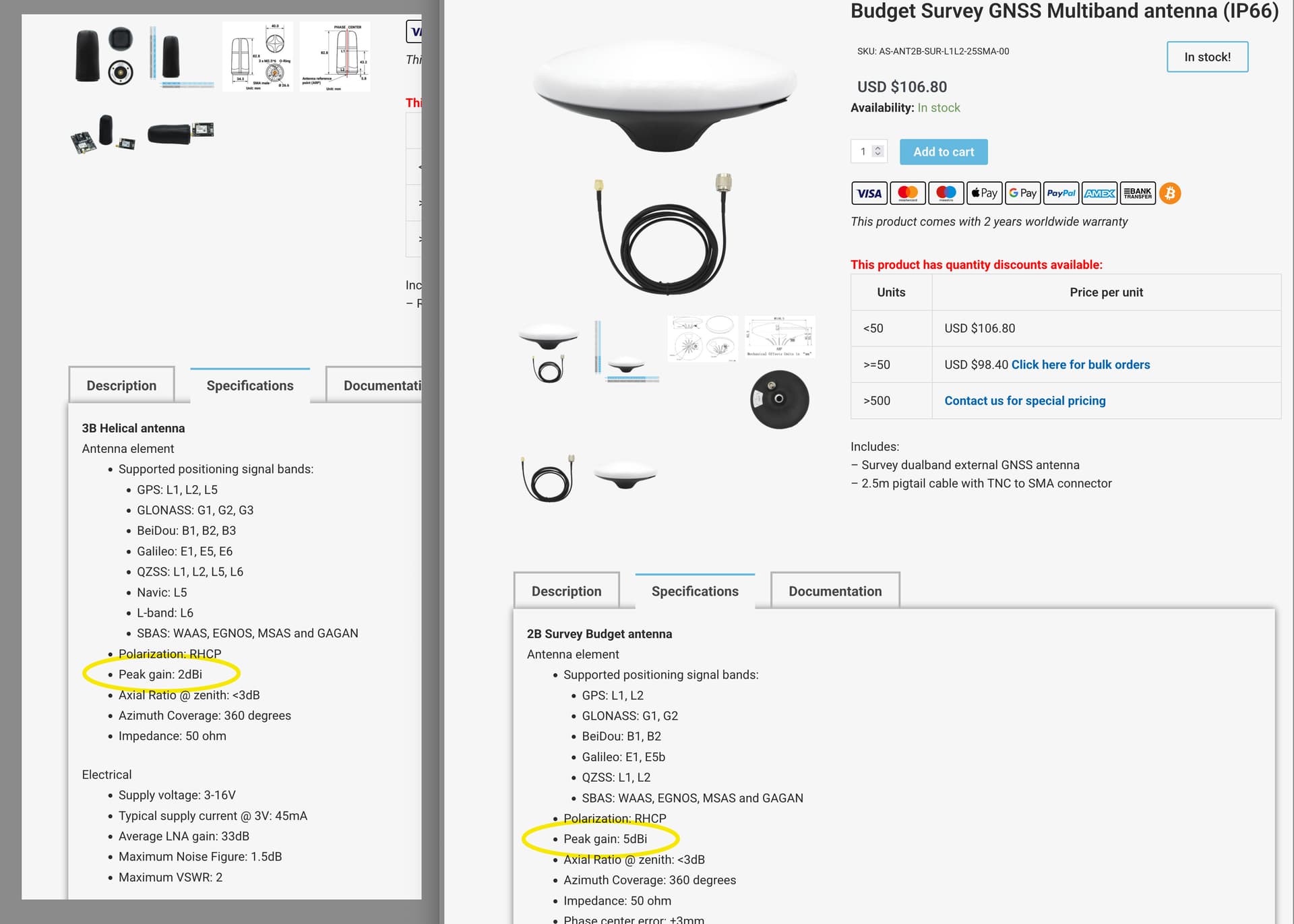
What model of helical antenna do you use ?
Cael,
If you are using the small black “can” helical antenna, that antenna is not a particularly high “gain” antenna. In my prejudiced stereotype those “can” antennae are designed for drones with an open view of the sky. The larger white “flying saucer” antenna below has twice (+3dB) the gain, which may help help you maintain adequate signal reception under tree cover.
From Ardusimple’s website:
If one is standing at the base of the trunk of a single mature oak, pine etc tree in an open field, one still has large amount of tree mass blocking the signal from directly overhead, and a very large mass of tree trunk blocking the signal from any satellites on the other side of the trunk.
I don’t know what the “professionals” do, but I would be tempted to cut an 8ft or 3m piece of thin lumber like a 1x2 and affix a compass to it and take my location measurements offset that distance from the trunk along magnetic north or south, and fix the data later “in post”. That offset might be sufficient to get you out from the signal shadow of the tree.