I could buy about 4-5 torches. My neighbors and I do need a licensed Surveyor for another project that touches four of our properties. The County is Quit Claiming an abandoned road to us for free, but we need to pay for the survey. As part of that I called 8 surveying companies in East TN. 2 never called back. 1 called and said sorry to busy. 5 that called back price range for the road project for the 4 of us was $19,420 to $15,536. I asked for getting extra pins or even flags (not licensed capped) placed on my property unrelated to the road project because they’d be out there anyways… $8,500 was my lowest bid, and that was only for “primary corners”, and 4 flags on the ridge which is 3,700ft long and has about 33 calls. I know its a complicated property, with a total of 130+ calls, but I just can’t afford that since I don’t need “legal” accuracy for the farming part of the survey.
For the Quit Claim on the road, eventually the licensed work will need to happen, but we need the housing boom here to slow down a bit. We currently live in a 8,000 parcel community being built out (Tellico Village TN) and the surveyors here are making good money. They are all driving brand new F350’s or Escalade level SUV’s. I’m a capitalist so I totally support that, but since I don’t need legal survey immediately, I can wait for the economics to improve or for the County to change their mind and help with survey costs. In the meantime to do fire breaks, the Prosumer still seems like it can work, and I will own a device that I can help my neighbors with their fire break marking etc staying safely within the borders of their properties.
I understand professional survey gear is expensive, that filing and researching all the legal paperwork is expensive, insurance covering any possible measuring mistakes isn’t cheap, so the bids for the road are probably reasonable. I just can’t afford that at the moment and my neighbors definitely can’t.
I think to flag the property the way I would like, probably 6-8 capped pins, verify current pins, flag all the calls, probably about $30,000 based on the road survey estimates.
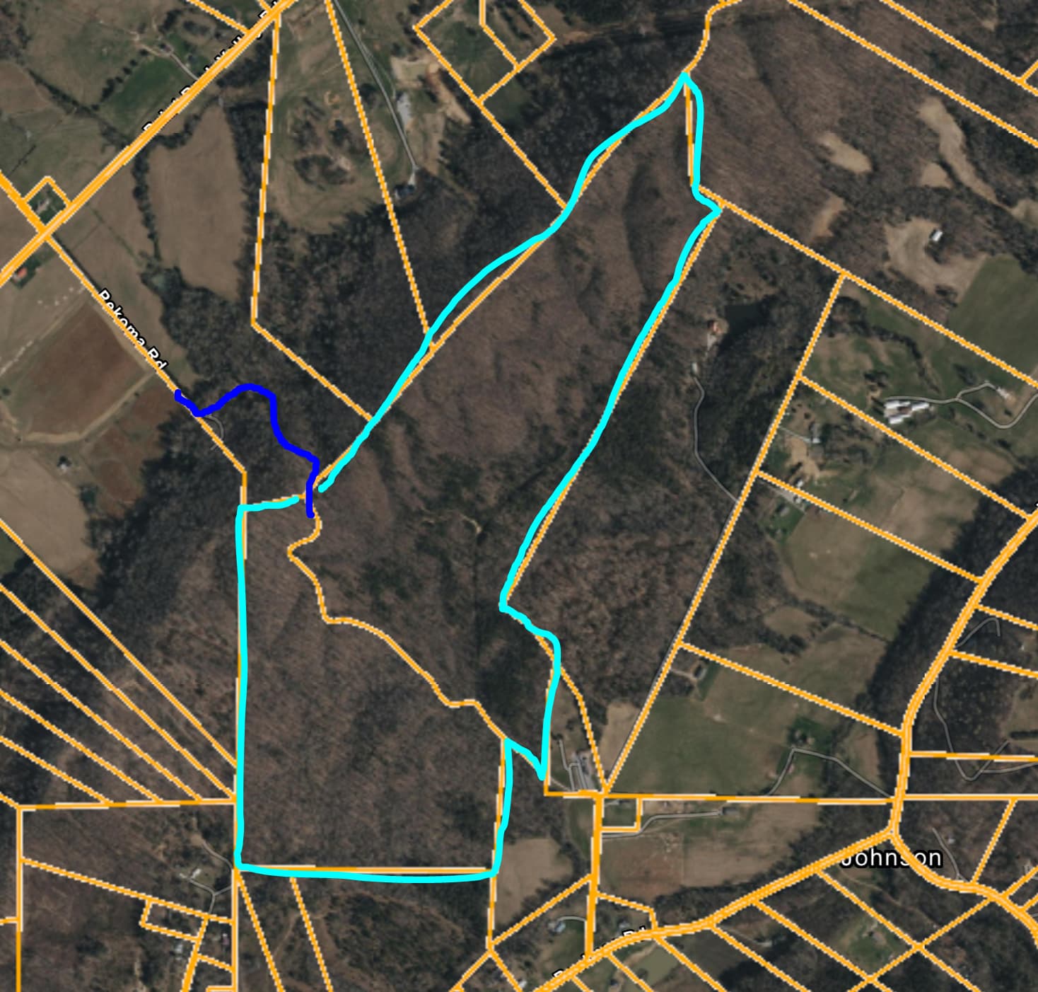
The Blue line is the Closed Road that needs the legal Survey. The teal/light blue is what I want to “self Flag” the pins.
The bottom parcel that is Idaho shaped only has about 9 calls not counting down the road.
@AORPLS Ryan, could you wire frame these for me please?
The second line South 4 degrees 40 minutes West[779ft] is a pin I found. The south end of that 779ft there is supposed to be a pin, but I did find a pulled up piece of T-bar post under leaves laying flat on the ground that was +/- 10ft of where iPhone GPS and Columbus GNSS said the iron pin should be.
I used a Columbus GNSS Data logger and got approximately 35.67422747 -84.57019874 at the start of that call (North End)
Compass Heading Mag +5.4 West
22 63 50
As Written means subtract about 5.4 from each heading 32N 20m would be ~26.9N
Reverse Mag +5.4W +/- 22
Feet
Note
311NW 58m
309NW 11m
50
Beginning at an iron pin corner on the Southwest margin of Johnson School house Rd, said iron pin being located North 48d 02m West 158.93 ft North 50d 49m West 169.70 ft from property of Johnson Valley Church
131SE 58m
129SE 11m
158.93
169.70 ~~~~~~~~ 328.63
Found Pin
found pin
184S 40m
50
South 4d 40m West 779.39 ft to iron pin corner
04N 40m
779.39
pin removed?
272W 34m
50
North 87d 26m West 1,512.98 ft to iron pin corner
92E 34m
1,512.98
02N 11m
50
North 2d 11m East 382.00 ft to an iron pin corner
182S 11m
382.00
00N 48m
50
North 0d 48m East 221.66 ft to an iron pin corner
180S 48m
221.66
01N 04m
50
North 1d 04m East 402.82 ft to a Point ?
181S 04m
402.82
Odd there is no pin???
03N 59m
50
North 3d 59m East 1,064.07 ft to an iron pin corner
183S 59m
1,064.07
71E 30m
50
North 71d 30m East 306.51 ft to an iron pin corner
251W 30m
306.51
32NE 15m
50
North 32d 15m East 156.13 ft to an iron pin corner at Westerly margin of road
212SW 15m
156.13
144SE 38m
50
South 35d 22m East 20.41 ft to iron pin at center of road
324NW 38m
20.41
213SW 13m 179S 51m
50
following center of the road two calls South 33d 13m West 67.66 ft South 00d 09m East 41.13 ft to iron pin center of road
33NE 13m 359N 51m
67.66
41.13
257W 49m
50
South 77d 49m West 20.45 ft to iron pin on Southwest margin of road
Ok, I will need to type up the other 27 calls of the 50 acre parcel. I had not typed those up since they are the internal border that joins the two parcels. Headed out for work now, but should be able to type it up tonight. Really appreciate your coaching and assistance on this!!
I know this is an old post but I found myself in the same situation converting deed bearing calls to LAT/LON point. There is probably an online tool that exists already to do this but I couldn’t find one. Per what others have said, I used a GNSS receiver (RTF Fixed) to record two known iron pins. From there I reordered the deed bearing calls so my POB (point of beginning) was one of the known iron pins.
If anyone is interested, the tool is available online. It will output a table of estimated LAT/LON points. Optionally, you can export the points as a KML to import into SW Maps app to easily locate the points with a GNSS receiver.
Note - you need to know when your seed bearings were recorded to look up the declination to account for magnetic north movement.
Welcome @Andrew74 , This is an AMAZING first post !
Your webpage is a great tool for the open-source RTK community.
I’m only aware of “paid” options inside of various professional tools that I’ve used.
I have a couple of technical questions (just to confirm my assumptions), but I think your Post deserves it’s own thread to make it easier for others to find it in the future. This is a big deal and a great contribution Andrew !
that’s great I will need to check that out. I have just started doing some pin readings and getting CLAUDE AI and occasionally ChatGPT to check out my accuracy by feeding AI the deed language and then my LAT/LON – my first test.. results
Accuracy in Centimeters:
Leg Pin 1 → Pin 2:
Error: 0.12 inches = 0.3 cm over 405.36ft
Leg Pin 2 → Pin 3:
Error: 0.48 inches = 1.2 cm (over 134.00ft distance)
This is using the new PointPerfect corrections NTRIP that I just started testing about 2 weeks ago
My deed points seem to have known about declination, as they appear to be spot on when I use a Suunto (+/- 0.5 degree) compass and correct for declination, but I have no idea when they were recorded. Perhaps 1980’s
Appreciate the kind words! If others could find it useful, I’ll revise the webpage to include more detailed instructions on using the tool and post a separate thread.
The source code is written in JavaScript so it’s visible to anyone who wants to look at the math.
I‘m not a surveyor by any means. The calculated lat/lon points could be more precise. Using it on my property that has 80+ corners, I was able to locate almost all my monuments within 6” of where the tool calculated they would be.
Technical - the tool “should” take into account the curvature of the earth. I tried multiple distance formulas and projecting to a horizontal plane. I wound up going with the Vincenty formula. It got me close enough. Open to criticism and suggestions to make the tool more useful.
Can’t wait to hear more!!! my deed has 96 deed calls/segments. The longest 2,677ft the shortest 7.35ft They were clearly getting paid by the call when they broke up this 800 acre farm into smaller parcels!!
Since you have known GPS points you can just keep adjusting the declination input until it aligns with your known points.
Unfortunately, my DIY GNSS receiver is only accurate to like 5-6 inches. My base station is from the public New York DOT and they only outputs MSM4 messages which doesn’t have the same degree of accuracy as a MSM7 base station.
What base station do you use for PointPerfect NTRIP?
Pile of stones from 1937 found with my DIY GNSS rover. Using an ESP32 BLE to connect to SW maps.
Looks exactly like my forest, just no snow in east Tennessee at the moment… 70F today. The Point Perfect correction is a subscription service. I was using PointPerfect MQTT Subscription for $8 a month, and it really struggled to maintain RTK FIX. Not exactly sure why, as the replacement PointPerfect NTRIP service has been amazingly solid even under deep/tall Pine trees. And on my test bed it is getting under 1 cm accuracy. One of my past tests of 6 remeasures on the same segment was +/-8mm (next day was 1.2cm though so… repeatability is key) I don’t actually need 1cm accuracy, as I am just putting in fire breaks, so +/- a foot would be fine, but… well if I can get 1cm, why not!!! Along one of the firebreaks I need to refresh below
I think your implementation is perfect for the intended use case.
One of my questions was to confirm my assumption that you didn’t perform a Grid-to-Ground calculation. In reality, it would take a Huge parcel to impact the results, when considering the intention is to get ya close for physical recovery of a pin. But the cheat would be to lookup the Scale Factor for the first known position and apply it to the measurements. But like I said, I think it’s perfect the way it is.
No Notes… which is rare for a Civil Engineer to say
I cant wait for the discussion thread.
[Edit] I just looked at the source…You do use a Scale factor
[Edit #2] AND a Least Squares adjustment. LoL, I should have looked at the source before posting. Great Job !
I’m tagging Nathan (@sparky) because I believe this is basically why he started developing the RTK lineup at Sparkfun years ago, and why we now have these awesome SF RTK products that anyone can afford.
It’s kind of wild to see how far we’ve come in 5 years. From this to this and more coming!
@Andrew74 - Please do create a separate post on the forum and educate us surveying luddites. I recommend a ‘why’ and ‘how’ explainer as many readers (ok, maybe it’s just me) are not familiar with deed and surveying work.
Planning on making a post once I have verified the math is accurate with further in field testing! @sparky
@ChrisO if you could share your deed description with me and some of your known RTK points, I will use it as another test case. I found your property but wasn’t able to find your county clerk’s online records repository.
@rftop thanks! I’m still trying to determine why my distance error from the measured points to the projected points is ~1ft. Either my GNSS receiver is not accurate enough or my math is formula is the issue. Most likely my GNSS receiver with the public base stations from NY state. I couldn’t afford a higher end SparkFun receiver kits at the moment, with the holidays and all so I had to make my own using a LG290P receiver. Hopefully, @ChrisO can verify with his receiver if the website’s math is accurate enough to recover monuments.
@Andrew74 our county deeds are still a walk in request, public records, but you have to go to the court house. I have the deed typed up into Google Sheets, and have the readings for those monuments I have found thus far. I will get you to them via PM shortly, and if I find some more when I go searching later this week I will get them to you.
It will be interesting to see how it does vs the AI thread I posted. I have found that using AI can get you close but verify. And or be really specific on prompting it, for example I found AI using only the first 4 decimal places of the Torch’s readings as it thought I was using my iPhone, so that thru things off. In another case some how it doubled the length of a segment that generated malarky. It’s has been a great learning experience for sure!!! PM with details coming in a few minutes….. Thanks for building the calculator and very willing to be a test case.
@Andrew74, here are a few of my thoughts for consideration and/or discussion.
Would it be worth a quick check (and display the results) of the loop closure calculation once a user finishes typing the meets and bounds description from their deed ? That’s a quick way to confirm that the user entered the calls from the deed correctly. IE: The first point (POB) and the last point are the same physical point/location when plotted
Also, how about a quick description of how the site localization is performed behind the curtains?
Typically, I only use 2 RTK Points (initially) when performing a site localization with RTK.
The parcel is fixed to a Real-World Position by RTK Point #1 (a found iron pin). Then the parcel is rotated to align with RTK Point #2. The 2 points (found monuments) should be as far apart as possible, not adjacent points/calls.
By using your website, the GNSS user doesn’t have to understand Coordinate Systems, Datums, Projections, Reference Frames, etc. Just use the same equipment and correction source for the initial deed localization (the initial 2 RTK Points, found Iron Pins) as they will use during the monument recovery after exporting the localized points from your website.
PS: The Scale Factor and Least Squares might be overkill for this application? I ran a few checks and the difference was ~50 ppm for a “typical” parcel…which is insignificant in this context. But I’m not recommending to remove it…hmmmm?
Good idea! I had it in an earlier version but the math was broken so I had removed it. I tried implementing the RTK localization for Rotation, Translation, and Scaling again…it appears to be working correctly but, that remains to be seen