I have been spending way too much time searching the Sparkfun website and the greater internet to find the best/simplest way to create a fairly accurate map of a 7 acre rhododendron garden. I have a hand drawn map that was created around 1968. It is not accurate. Plants are no where near where the map says and may of the plants have died.
The garden has significant tree cover (mix of big leaf maple and fir). I’m thinking this would be a winter project to lessen cover. Those are the conditions.
I’ve looked at SW Maps (very clunky on iOS and I’m not going to buy an android for this, I’m a volunteer in this public garden). I’ve looked at QGIS (very overwhelming). I know what control points are and how to establish baselines from my working days diagramming outdoor crime scenes, but I am NOT a surveyor. I’m not sure I need that level of precision. I just need to be able to find a specific plant (often missing labels because people steal them) from the resulting map.
I’ve looked at the Torch, Mosaic and other RTK GNSS receivers. I’d like to know if anyone has suggestions for the hardware end of this project, but I really need to understand how I can collect the points (app) with some attributes/fields associated with each (maybe even a picture just as a check for accuracy) as quickly and easily as possible. I have around 500 plants to record along with water quick disconnects and a few control points. And then, how do I get all these points, that will likely take days or even weeks for me to collect, displayed on a map that I can then save and print as a pdf? Seems simple, but I’m finding it isn’t.
My personal opinion for a budget-minded project : Look at the Sparkfun PostCard and SW Maps.
You can manually create your layers in SW Maps, or use their Template Builder.
As far as generating your final Map, there are dozens of options with a huge range of complexity. Starting off at the simplest would likely be exporting the SW MAPs features to KMZ/KML, shapefiles, etc from your iPhone. Or you can export a Points.txt file to use with any CAD program.
Assuming you are in the US, what State are you in? Many States have free networks for NTRIP corrections that work great with the Postcard.
Thanks for the recommendations. The PostCard looks like it has the same specs as the Torch. No doubt there is some variant in the Torch. Unfortunately, I’m not an electronics DIY, so I’m not sure I could make the PostCard work. I assume I’d have to hook up a battery of some sort and an antenna and figure out an enclosure. It rains a lot in Washington State; particularly beginning in November.
Thanks for pointing me in a direction however. I’ll have to do some more research.
I guess you’ll need to decide if you want/need RTK accuracy or not.
IE: do you want to locate/find a position within a couple of cm’s or a couple of meters.
For RTK, you’ll need a correction source for the Torch. Washington has a Statewide RTK Network, but it’s $1,900 per year (free 90-day account).
PointPerfect Flex RTCM over NTRIP ($10-15/month) would likely be a better choice if you decide to go RTN (a network Rover receiving corrections over the internet).
If you decide that a meter or two of accuracy is OK for your application (no RTK), then the Torch might be considered overkill. A dual or tri-band receiver & antenna using free SBAS corrections would get you there. However, since you mentioned rain…it’s hard to beat the torch
Thank you. That is very helpful. I’ve been looking at the torch and vacillating between it and the express. Could you tell me if the Galileo HAS capability is effective? 1/2 a meter accuracy would be fine, maybe even a meter, but tighter is always better I plan to tie in 12 quick disconnect water valves and use them as reference points. We use them to water the garden and they can be hard to find. And yes, we normally get a consistent rain. Unfortunately it’s only rained a few days in the past four months. Looks like this weekend will be wet however.
I think HAS is viable for your particular application…that’s a good idea.
One consideration to keep in mind:
We usually recommend collecting the locations of assets with the best possible method, even if you intend to use a “less accurate” method to recover those assets in the future.
However, since you likely won’t have access to the tools to switch between coordinate systems and reference frames…I’d probably suggest using the same method for the original Mapping of the Assets as you intend to use in the future to “find” them.
IE: If you’ll use HAS in the future, you probably want to collect/map with HAS in this situation. Don’t use RTK (free trial, or a couple of months of PointPerfect) for the original collection and HAS later on…unless you can perform the transformation. You’ll be leaving some accuracy on the table, but your life will be easier.
The Downside: Having a Torch means you could have located the assets with PointPerfect RTCM to the size of a dime…instead of using HAS
Ok, that’s good to know. Maybe I’ll do some tests to see how far off I’d be off. I tried my iPhone with SW Maps and it says I have an error of 48 feet horizontal. That’s certainly not worth my time to measure. If necessary I can sign up for the RTK if I can turn it off once I’m done. I plan to tag each plant with a unique number and cross reference to previous tags (if present; 50% are missing) and there should be a drastic improvement over the 1968 method of blind reconning.
Not sure if this helps but PyGPSClient allows users to define and display their own georeferenced offline maps, and it will overlay track or location points based on GNSS navigation data.
You mentioned QGIS earlier in the post - it’s a very powerful tool which can indeed seem overwhelming, but there’s a simple wiki here which explains how to create georeferenced maps for PyGPSClient using QGIS.
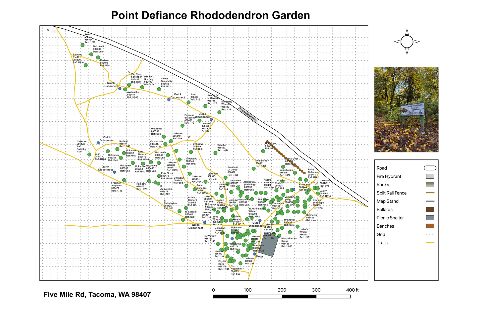
Thanks for the suggestion. It was a pretty steep learning curve, but I’ve been able to figure out SW Maps and QGIS enough that I’m going to be able to produce the kind of map I envisioned. I’m certainly only scratching the surface with QGIS, and the user interface with QGIS is quirky and not always intuitive, but I can’t complain too much since both SW Maps and QGIS are free.
This is one version of the map. I’ve set up 5 in QGIS, each showing different sets of features. I still have about half the garden to finish measuring.