PaulZC:
Can I ask how you are collecting the satellite sky position data? Are you connecting u-center to the UBLOX CONFIG port and doing all of the logging and visualization directly in u-center? Or are you logging NMEA and/or UBX-NAV-SAT to microSD card and then replaying the logged data through u-center?
I've tried it both logging through the ublox usb port, and through the micro SD. Same issue.
PaulZC:
I think this has to be a multi-path reflection phenomenon. Maybe the house wall to the North has reflective foil in it? Or is metal-clad? Or otherwise creating a strong reflected signal?
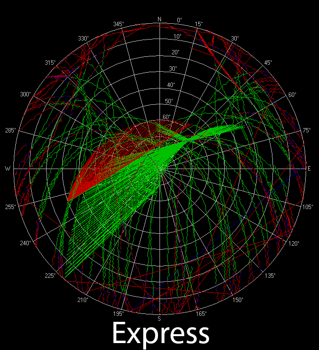
The house in question is my own so I can, with confidence, say that it's not metal clad nor does it have any metallic/foil wrap. Regardless though, I don't think this can be explained by a muti-path issue (at least not directly, see next paragraph). The u-blox receiver / TOP antenna is not actually "tracking" the satellites. The antenna/receiver picks up the signal from the sat but it doesn't know which direction the signal came from. For that you would need an antenna array and a phased array capable receiver. So, even if there is a MP issue due to a reflection off the house, the receiver would just see that as a signal that's taking slightly longer to get to it and this would introduce some position error into the fix. The receiver only knows where the signal/satellite is from the ephemeris data it receives.
PaulZC:
The only other explanations I can think of are that the GNSS module is somehow getting the satellite identifiers confused, or mis-decoding the satellite ID. Or that the satellites themselves are broadcasting the wrong identifier? But both of those would mean something had gone seriously wrong.
I'm totally guessing, but it *seems* like the receiver is somehow getting confused on the timestamp of when it received the signal from the sat in question and momentarily puts the sat location to a different part of the orbit (or different day altogether). Either that or it's getting confused which sat the signal is coming from and puts the sat on a totally different orbit -- although not sure why it would have the connecting lines then. As you said though, I don't think this is caused by the sat sending incorrect data as that would be a *serious* problem that would have been caught. My guess is that there is some bug in the u-blox firmware. Given that I get the same result with older firmware, if it is a bug, it has been around for a while and something about my specific config/setup is causing it to manifest. So perhaps there is some MP issue that's causing the receiver to run a correction/compensation algorithm and that algo has a bug in it. Again totally a guess though.
PaulZC:
It depends on the satellite orbits, but you will have satellites to the North of you. I think the ‘hole’ in your plots is caused by the house blocking the signal.
I also don’t believe that there would be any satellites directly to the north of me. The hole on the sky plot is due to the fact that GNSS sat orbits are inclined around 55-65 degrees, and given my latitude, that means they should just make it overhead , which is what you see in the plot. If you took the same plot at the equator you wouldn’t see any sats at the very top and bottom of the plot and as you move away from the equator the hole moves down from the very top/bottom of the plot, until it’s directly overhead when you get to the north/south pole. You can run the predictive sat visibility analysis in rtklib to verify.
Edited for clarity/quotes.